
Insurance & Loss Adjusting

Fire, Flood & Escape of Water Property Documentation

Drone Inspections • 360° Virtual Tours • Point Cloud Surveys • Photogrammetry • Digital Twins

Supporting Loss Adjusters, Insurers, Chartered Surveyors & Contractors with Clear, Accurate and Defensible Property Data.

UK-Wide Coverage

Contact Us

Capture Critical Evidence Before It Disappears

After a fire, flood or escape of water incident, a property can change rapidly. Emergency works begin, materials are removed, drying programmes start and damaged areas are stripped back.

Without an accurate record of the building condition at the earliest opportunity, valuable evidence can be lost.

Rotorgraph Surveys helps loss adjusters, insurers, Chartered Surveyors and contractors create a clear digital record of the property using drone inspections, 360° virtual tours, point cloud surveys and photogrammetry.

Whether you need to assess damage, validate a claim, scope reinstatement works or reduce repeat site visits, our documentation services provide the accurate information needed to make confident decisions.

Fast mobilisation. Accurate capture. Defensible evidence.

Contact Us

One Site Visit. Complete Property Visibility.

Major loss claims often involve multiple stakeholders, including loss adjusters, insurers, Chartered Surveyors, contractors, architects and property owners. Each party requires access to accurate information in order to assess damage, scope remedial works and progress the claim efficiently.

Traditional inspections typically rely on photographs, handwritten notes and limited site attendance. Once the visit is over, valuable context can be lost and further visits are often required.

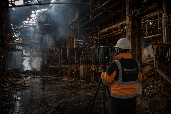
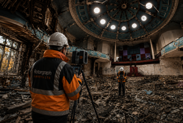
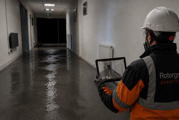
Rotorgraph Surveys combines drone inspections, internal 360° virtual tours, point cloud capture and photogrammetry to create a comprehensive digital record of the property.

This allows stakeholders to remotely revisit the site, review findings, verify measurements and inspect areas of interest long after the initial survey has been completed.

The result is improved collaboration, fewer repeat site visits and a clearer understanding of the property’s condition throughout the lifecycle of the claim.

One visit. Multiple outputs. Complete visibility.

Contact Us

Clear, Defensible Property Evidence

Major loss claims often require decisions to be made quickly and with confidence. Whether assessing fire damage, flood damage, escape of water incidents or structural concerns, having access to accurate visual evidence is essential.

Rotorgraph Surveys captures detailed property data using a combination of drone inspections, 360° virtual tours, point cloud surveys and photogrammetry. Every survey is designed to create a clear and reliable record of the property’s condition at the time of inspection.

From large-scale commercial losses to individual residential claims, our documentation allows stakeholders to review damage remotely, validate findings, assess scope of works and make informed decisions without relying solely on site attendance.

The result is greater transparency, improved collaboration and a permanent digital record that remains available throughout the lifecycle of the claim.

Contact Us

The Information Stakeholders Need To Move Forward

Following a fire, flood or escape of water incident, multiple parties are often involved in assessing damage and planning the next steps. Loss adjusters, insurers, Chartered Surveyors, contractors and property owners all need access to accurate information in order to make informed decisions.

Rotorgraph Surveys provides a comprehensive digital record of the property, combining drone inspections, internal 360° virtual tours, point cloud surveys and photogrammetry into a single, accessible dataset.

Rather than relying solely on photographs and written notes, stakeholders can remotely revisit the property, review evidence, verify measurements and gain a clearer understanding of the building’s condition long after the initial site visit has taken place.

The result is improved communication, reduced uncertainty and a more efficient route from assessment through to reinstatement.

Accurate data. Better decisions. Faster claim progression.

Contact Us

A Complete Documentation Solution

Managing a fire, flood or escape of water claim often requires input from multiple stakeholders, each needing access to accurate and reliable information.

Rotorgraph Surveys brings together drone inspections, internal 360° virtual tours, point cloud surveys, photogrammetry and digital twin technology to provide a comprehensive property documentation service from a single instruction.

Rather than coordinating multiple consultants and site visits, stakeholders receive a clear and consistent dataset that can be used to assess damage, validate scope, support reinstatement planning and monitor progress throughout the lifecycle of the claim.

Whether documenting a residential property, commercial building, industrial facility or major loss event, our aim is simple: provide the information needed to make confident decisions, reduce uncertainty and keep projects moving forward.

One instruction. Multiple deliverables. Complete property visibility.

Contact Us

Experience You Can Depend On

Fire and flood-damaged properties often present challenging environments, tight timescales and multiple stakeholders requiring access to reliable information.

Rotorgraph Surveys has worked alongside insurers, loss adjusters, Chartered Surveyors, architects, contractors and property managers to document everything from individual residential claims through to large-scale commercial losses.

By combining specialist survey technology with practical site experience, we provide the accurate property data needed to support informed decisions, reduce uncertainty and move projects forward with confidence.

Trusted data. Professional delivery. Nationwide coverage.

Contact Us

Case Studies

Discover more from our recent Case Studies

Major Industrial Fire | Digital Twin & Point Cloud

Major Industrial Fire | Digital Twin & Point Cloud

Kings Hall Church Fire Survey, Southall | Digital Twin & Point Cloud

Kings Hall Church Fire Survey, Southall | Digital Twin & Point Cloud

Warehouse Flood Damage

Warehouse Flood Damage